Long before drones, helicopters and aircraft turned overhead photography into an everyday tool, a Royal Engineers officer sent a small balloon above Halifax with a camera attached. The resulting photograph became the first aerial photograph taken in Canada.
Today, looking down at Halifax from above is almost unremarkable. A drone can rise over the harbour in seconds. Aircraft routinely carry sophisticated digital cameras that can photograph large areas with remarkable precision. Mapping agencies can combine thousands of overlapping images to build detailed maps and even three dimensional models of the landscape.12
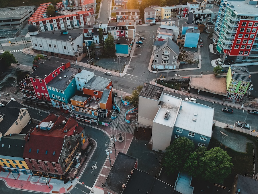
Aerial photography is, in its simplest form, exactly what it sounds like: a photograph taken from the air. For mapping and surveying, the most useful images are generally taken vertically, with the camera pointed straight down. Modern aerial cameras are designed to capture a rapid sequence of images while minimizing distortion, and they can be linked to navigation systems so each photograph can be associated with precise geographic coordinates.1
Aircraft normally fly a planned series of parallel flight lines while the camera takes photographs in succession. The images overlap one another, often by roughly 60 per cent along the flight path and about 30 per cent between adjacent flight lines. That overlap is important because it allows surveyors and photogrammetrists to view the landscape in three dimensions and make measurements from the photographs.1
Modern systems have also moved from film to digital imaging. Digital aerial cameras record light electronically and allow images to be quickly stored, processed and analysed. Aerial photography is now used for everything from mapping and urban planning to forestry, environmental studies and monitoring changes in the landscape.23
Canada’s National Air Photo Library contains millions of aerial photographs documenting the country over many decades. Natural Resources Canada describes aerial photography as a way of recording the changing natural and built landscape, while its historical collections allow researchers to compare places at different points in time.34
But the story of aerial photography in Canada did not begin with an airplane.
It began over Halifax.
A camera, a balloon and Citadel Hill
In 1883, Captain Henry Elsdale of the Royal Engineers conducted experiments over Halifax using a small tethered balloon carrying a camera. The camera was equipped with an automatic timing mechanism that allowed it to make an exposure after the balloon had been raised to the required height.5
At least one surviving vertical photograph was taken from approximately 1,450 feet above Halifax. It shows the Halifax Citadel from above and is identified by the Nova Scotia Archives and Halifax Municipal Archives as the first aerial photograph taken in Canada.56
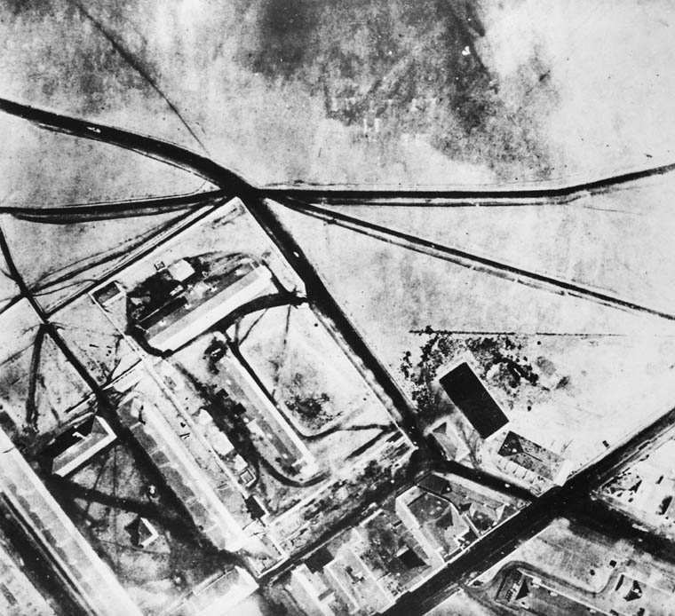
That makes the image particularly remarkable today. It was not taken from an airplane, because powered flight was still decades away. There was no drone hovering overhead and no pilot sitting behind a camera.
Instead, the camera had to go up on its own.
Elsdale’s work was part of a much larger interest among military engineers in using balloons for observation and surveying. Research into his Halifax experiments shows that he was testing small tethered balloons, lightweight cameras and automated exposure systems, with the possibility of using aerial photography for both military and civilian purposes.8
The approach was ingenious but primitive by modern standards. A balloon could carry the camera above the ground without requiring a pilot or aircraft, while the tether provided at least some control over where the balloon went. The automatic shutter solved another problem: someone did not have to physically operate the camera at altitude.58
The idea was particularly suited to a place such as Halifax.
Why Halifax?
Halifax had been established by the British in 1749 because of its strategic position on one of the world’s great natural harbours. Citadel Hill was chosen as the site of Halifax’s principal defensive position because its elevation offered commanding views over the town and harbour.9
The fort visible in Elsdale’s photograph was the fourth Halifax Citadel. Construction began in 1828 and continued until 1856. By the time the photograph was taken in 1883, the Citadel had already been watching over Halifax for decades and remained an important military installation.9
The location also helps explain why this particular experiment happened here.
From the hill, military authorities were already accustomed to thinking about the city as a landscape to be observed, mapped and defended. An elevated photograph could provide a completely different perspective on fortifications, roads, buildings and the surrounding terrain.
The photograph was therefore more than an unusual experiment in photography. It demonstrated that a camera could be lifted hundreds or even more than a thousand feet into the air and used to record the ground below in a way that could eventually support military surveying and mapping.8
What can we actually see in the photograph?
The original 1883 image is not a sweeping modern panorama of the entire Halifax Regional Municipality. It is a vertical photograph focused on the Citadel Hill area.
The Halifax Municipal Archives describes the image as the first aerial photograph taken in Canada and identifies the Citadel as its subject.6 Library and Archives Canada separately records an August 1883 vertical aerial photograph of the Halifax Citadel, while another archival record specifically identifies a vertical aerial photograph of the Citadel’s glacis barracks from the same period.710
Viewed today, what is perhaps most striking is how recognisable the geography remains.
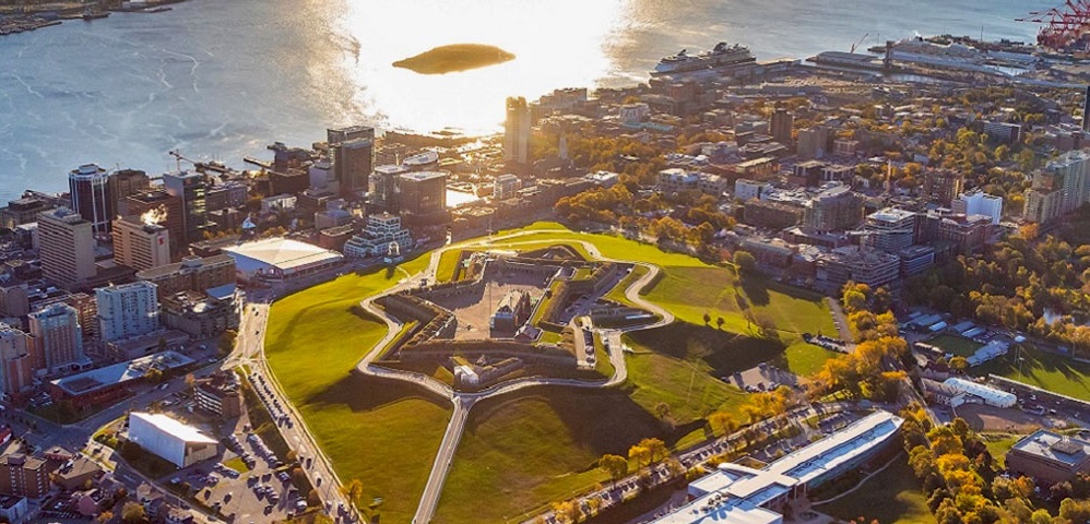
Citadel Hill is still in the heart of Halifax. The defensive grounds are still there, and the surrounding street pattern still reflects the city’s historic development around the hill and harbour. Parks Canada describes the Citadel as occupying a strategic hilltop overlooking Halifax Harbour, a position that has made the site important to the city’s military history for more than two centuries.9
Yet almost everything around it has changed.
The Halifax of 1883 was a much smaller city. There was no modern downtown skyline, no glass towers rising above Spring Garden Road, no container terminals stretching along today’s waterfront and no network of modern roads carrying traffic through the city.
The harbour remains, the hill remains and the basic shape of the peninsula remains, but the density of Halifax has transformed.
That is one of the great strengths of aerial photography. From ground level, changes can sometimes be difficult to appreciate because individual buildings come and go without altering the broader experience of a neighbourhood. Seen from above, those changes become much easier to understand.
From balloons to airplanes
The limitations of Elsdale’s system soon became obvious.
A tethered balloon could rise, but it was restricted by its tether and by the conditions affecting the balloon. An airplane offered something a balloon could not: controlled movement over a chosen route.
As aircraft became practical, photographers began experimenting with cameras mounted on planes. Early aerial photographs could be taken obliquely from the cockpit, while vertical photographs required photographers and equipment to operate in considerably more difficult conditions.5
Aerial photography became especially important during the First World War, when photographs taken from aircraft were used for reconnaissance and to document enemy positions. Nova Scotia Archives notes that by 1915 the German trench system had been photographed extensively and the resulting imagery studied by British military headquarters.5
Canada quickly became interested in the possibilities beyond military reconnaissance.
Natural Resources Canada traces the development of systematic Canadian aerial photography to the early 20th century, particularly the work of Surveyor General E.G.D. Deville. The creation of the Air Board in 1919 and the availability of aircraft helped move aerial photography from experimental balloon platforms into organized airplane surveys.11
By the 1920s, regular flights were being used for mapping, forestry and other forms of surveying across Canada.11
The camera no longer needs a photographer
By the time professional aerial surveys became established, the basic idea behind Elsdale’s experiment was still recognizable: put a camera above the ground, point it down and capture enough detail to understand the landscape.
What changed was almost everything else.
Modern aerial cameras can capture large, high resolution digital images at speed. Navigation and positioning systems allow each photograph to be tied to its precise location, while motion compensation reduces the distortion caused by the aircraft moving during exposure.2
The photographs are also designed to work together rather than simply as individual pictures. Overlapping images can be processed using photogrammetry, allowing measurements to be taken and three dimensional information to be extracted from the landscape.12
For a modern survey, an aircraft might repeatedly pass over an area in carefully planned flight lines, building up a grid of overlapping photographs. The result can be used to create accurate maps, orthophotos and elevation information.
The National Air Photo Library has been building this kind of historical record for decades. Its collection includes aerial surveys dating back to the 1920s and preserves repeated coverage of many parts of Canada, allowing researchers to see how landscapes have changed over time.4
That makes today’s aerial photography useful not only for understanding what is there now, but also for reconstructing what came before.
Halifax has been photographed from the air for generations
The 1883 photograph was only the beginning of Halifax’s relationship with aerial imagery.
The Nova Scotia Archives’ aerial collection includes much later views of Halifax and Dartmouth, including photographs taken during the 1930s. The Richard McCully collection contains 221 surviving glass plate negatives from a 1931 aerial survey of Nova Scotia, including images of Halifax, Dartmouth and other communities around the province.5
Those photographs provide a fascinating bridge between Elsdale’s experiment and modern aerial photography.
By 1931, the camera was no longer hanging from a balloon. Harold Reid photographed the landscape while pilot Marty Fraser flew the aircraft. The resulting images captured streets, buildings, businesses, farms, waterfronts and industrial sites from above.5
The collection even shows parts of Halifax that have since disappeared or changed significantly.
That is what makes aerial photography so valuable as a historical record. A single image can preserve not just a building, but its relationship to every street, open space, industrial site and waterfront feature surrounding it.
The 1883 photograph does something similar on a much smaller scale.
More than 140 years later, the landscape around Citadel Hill has changed dramatically, but the hill itself remains recognisable. The photograph captures a moment when photography was still learning how to look at the world from above.
Today, Halifax can be photographed from aircraft, drones and satellites with extraordinary detail. What once required a Royal Engineers officer, a small balloon and a specially rigged camera can now be done routinely.
Yet the principle has hardly changed.
Raise a camera above the city, look down and record what is there.
In 1883, that simple idea was enough to make Halifax part of the history of aerial photography in Canada.
Sources and notes
- Natural Resources Canada, “Concepts of Aerial Photography.” Provides the fundamentals of vertical aerial photography, flight lines, photographic overlap, stereoscopic coverage and the use of aerial photographs for mapping and measurement.
Source
↩ - Natural Resources Canada, “Cameras and Aerial Photography.” Covers modern aerial cameras, digital imaging, navigation systems, motion compensation, vertical photography and photogrammetry.
Source
↩ - Natural Resources Canada, “About Aerial Photography.” Explains the uses of aerial photography for mapping, planning, environmental studies and documenting changes in the landscape.
Source
↩ - Natural Resources Canada and Library and Archives Canada, National Air Photo Library. The National Air Photo Library contains extensive historical aerial photography of Canada and allows researchers to examine landscape change over time.
Source
↩ - Nova Scotia Archives, “Nova Scotia from the Air: The Richard McCully Aerial Photograph Collection, 1931.” Includes the history of Captain Henry Elsdale’s 1883 Halifax experiment, the 1,450 foot photograph, the development of aerial photography and the later McCully and Reid aerial surveys of Nova Scotia.
Source
↩ - Halifax Municipal Archives, “First aerial photograph taken in Canada.” Documents the Halifax archival copy of the 1883 photograph, including its caption, provenance and description.
Source
↩ - Library and Archives Canada, “Citadel, Halifax, N.S. from a balloon.” Records the 1883 photograph and identifies the Halifax Citadel as its subject.
Source
↩ - Dirk Werle, “Tinker, Mapper, Soldier, Spy: Captain Henry Elsdale’s Pioneering 1882–83 Experiment with Small Balloons and Vertical Aerial Photography in Halifax, Canada,” Canadian Journal of Remote Sensing, 2019. Provides additional research on Elsdale’s experiments with lightweight cameras, tethered balloons, automated timing and the potential military and civilian applications of aerial photography.
Source
↩ - Parks Canada, Halifax Citadel National Historic Site. Provides the history and strategic importance of Citadel Hill, including the development of the fort and its commanding position over Halifax Harbour.
Source
↩ - Library and Archives Canada, Photographs and illustrations collection. Includes the archival description of a vertical aerial photograph of the Halifax Citadel’s glacis barracks from August 1883.
Source
↩ - Natural Resources Canada, “Aerial Photography in Canada.” Covers the development of aerial photography in Canada, including the role of E.G.D. Deville, the Air Board and the establishment of regular aerial photography for mapping and forestry.
Source
↩